Thanks to Plato’s account of the lost city and Google Earth, new visual and arithmetic clues suggest that the mythical city of Atlantis may have been hiding in plain sight the entire time, in rather an unlikely place.
Since Plato first described it in his dialogues in 360 BC, the legend of Atlantis has traveled down the ages and only got stronger as centuries wore on.
As the legend goes, Atlantians tried to invade Athens, but were pushed back, and had to endure the wrath of gods pouring down as a mighty deluge that engulfed the city. Atlantis sank, never to be seen ever again.
Plato’s account of Atlantis is supposedly suggesting that tyrannical powers can’t triumph over organized democratic states, which is a major theme of his The Republic, written a few years earlier.
“This [invading] power came forth out of the Atlantic Ocean, for in those days the Atlantic was navigable; and there was an island situated in front of the straits which are by you called the Pillars of Heracles,” so went the recount of Plato (in Timaeus) who goes on to describe the fate of Atlantis, “in a single day and night of misfortune all your warlike men in a body sank into the earth, and the island of Atlantis in like manner disappeared in the depths of the sea”.
To this day, Atlantis is still a dream for some archeologists, and a breeding ground for conspiracy theorists, who all believe the city was a real ancient advanced civilization that vanished due to a natural disaster after it has dominated the world.
The Lost City of Atlantis is the Eye of the Sahara
Most assumed that Atlantis, thought to have been once an idyllic paradise and a highly advanced society, would be under the water somewhere in the Atlantic ocean or the Mediterranean sea, or under the ice of Antarctica.
Even armed with modern science and tech, and more accurate translations of Plato’s account, no one has come close to finding this version of Atlantis.
Now, we may have new clues as to the whereabouts of Atlantis island that remained sight unseen since it went under around 9600 BC.
Propounded by a YouTube channel called Bright Insight, a new theory, which fits Plato’s description nicely, suggests Atlantis has been hiding in the Sahara all along.
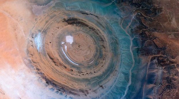
Located in Mauritania (Northwest Africa), about 250 miles inland from the Atlantic Ocean, the Richat structure is more known as the Eye of the Sahara or the Eye of Africa.
The Eye of the Sahara is a prominent circular geological structure that, at 30 miles across, is so huge that NASA astronauts used it as a landmark. From the ground, it’s hard to discern, but, thanks to satellite imagery of the Gemini 4 first in 1965, then other space missions , we finally got a comprehensive view of this giant bulls-eye.

First thought to be a meteorite impact site or the remnant of an ancient volcano that erupted long ago, the Richat structure is now considered to be the natural product of an uplift shaped by erosion, which formed over a hundred million years ago.
Bright Insight, however, has another theory that aspires to explain the origins of both Atlantis and the Eye of the Sahara by suggesting they are the same, or, more accurately, the latter is the ruinous remains of the former.
Bright Insight claims the Eye of the Sahara to be “the most likely location for the lost city of Atlantis as it matches so many precise details of what Plato wrote”.
Atlantis… in Google Earth
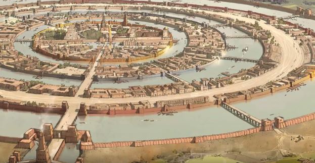
With its almost perfect circularity and measurements of it concentric circles, which can’t be explained by natural elements like erosion, the Eye of the Sahara fits the description of Plato. According to the philosopher, Atlantis was made of “alternate zones of sea and land, larger and smaller, encircling one another; there were two of land and three of water, which he turned as with a lathe out of the center of the island, equidistant every way”.

The first clue is that if there had been water in the Eye of the Sahara, there would be three rings of water and two of land, as Plato described.
The second clue, according to Plato’s texts, is that Atlantis disappeared 11,600 years ago, which could have coincided with a comet event (the Younger Dryas theory) that just might have caused the destruction of Atlantis, maybe by a tsunami.
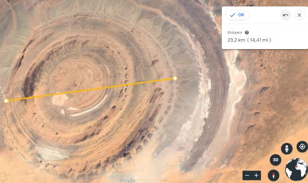
The third clue is that Plato said the diameter of the Atlantis island was 127 stadia, which is an ancient Greek distance unit that’s 607-630 feet (185-192 meters). So the diameter of the city of Atlantis was 127×607 stadia, or 14.6 miles (23.5 km).
Measurements in Google Earth give you anywhere between 20 to 24 km, which is very close.

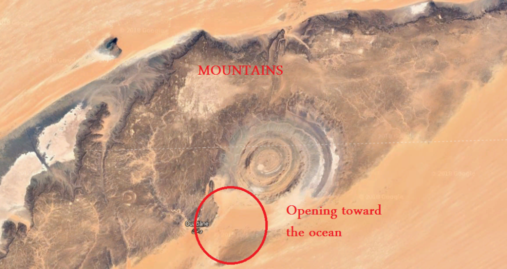
Another hint: “The mountains of the island of Atlantis were celebrated for their size and beauty,” said Plato, “The surrounding mountains of the city flow with rivers. This part of the island looked toward the south and was sheltered from the north”.
The Eye of the Sahara happens to be encircled with a chain of mountains on the north side, and satellite imagery shows traces of many ancient rivers on the sides of these mountains.
Picture these rivers before they dry up, water spilling around the island of Atlantis, and the lush vegetation that could once have covered this desolate place.
Plato says the city opens up to the ocean, and you can see in the image below that matches that description very well, and the mountains.

There are many other clues that all point out that the Eye of the Sahara could well be the legendary Atlantis.
For example, Plato also said that the city had elephants in great numbers, and archeologists have found many skeletal remains of elephants in the area, and there are also rock art depictions of elephants there.
Although this YouTube channel brings something new to the table, this is not the first time that the Eye of the Sahara has been suggested as the location of the lost city of Atlantis.
More: Possible Site of Atlantis Found Using Satellite Imagery


